Area Description
The study area, namely the Levantine area, is located in the Eastern region of the Mediterranean Sea and extends from 28° E to 36° E and from 30° N to 36° N. It is mainly characterized by the presence of the Levantine Basin, a small basin surrounded by continental masses in the Easternmost part of the Mediterranean Sea and the Herodotus Basin in the Western part. The deep crustal structure of the Eastern Mediterranean Sea has been a matter of debate for a long time and there is still no agreement on the nature of the crust nor on its age.
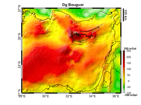
Gravity Data
- Compilation of latest GGMs combined with terrestrial (airborne and shipborne) dataset
- Grids of gravity anomalies and other derived products, derivatives and transforms (e.g. full tensor, THD, Tilt Angle etc.)
- Spatial Resolution: 1.6 km
Geological Data
- Full 3D geological model in terms of density distribution
- Regular grids of principal geological horizions (bathymetry, various sediments bottoms, basement and Moho) build from a compilation of latest available models and interpreted seismic profiles
- Spatial resolution: 1.6 km
Further Insight
The available results of a gravity constrained Bayesian inversion performed with proprietary software are:
- Full 3D geological model in terms of density distribution
- Regular grids of principal geological horizons
- Spatial resolution: 1.6 km